
Garmin Navionics+ Large Chart | Blank Downloadable Card
September 4, 2026
C-MAP REVEAL East Mediterranean Chart | M-EM-Y111-MS
September 4, 2026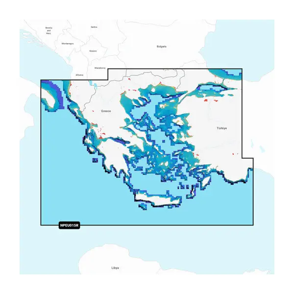
Original price was: 260.00€.250.00€Current price is: 250.00€.
The Garmin Navionics Platinum+ Aegean Sea & Sea of Marmara marine chart delivers premium, multi-layered cartography for compatible Garmin chartplotters. Designed for anglers, sailors, and motor yacht operators navigating throughout the Aegean Sea and the Sea of Marmara, the Garmin Navionics Platinum+ Aegean Sea chart card combines detailed nautical charts with advanced visual features to enhance situational awareness on the water.
Stock: available
Garmin Navionics Platinum+™ – Aegean Sea & Sea of Marmara
Overview
The Garmin Navionics Platinum+ Aegean Sea & Sea of Marmara marine chart delivers premium, multi-layered cartography for compatible Garmin chartplotters. Designed for anglers, sailors, and motor yacht operators navigating throughout the Aegean Sea and the Sea of Marmara, the Garmin Navionics Platinum+ Aegean Sea chart card combines detailed nautical charts with advanced visual features to enhance situational awareness on the water.
Built with Garmin’s flagship Platinum+ technology, this microSD™/SD™ chart card features high-resolution bathymetric contours, high-target Relief Shading, high-density satellite imagery, and 3D View perspective modes. With Auto Guidance+™ technology and an included 1-year subscription to daily chart updates, it offers an all-in-one navigation solution for precision plotting and underwater visualization.
Main Features
- Premium Garmin Navionics Platinum+™ cartography
- Coverage of the Aegean Sea & Sea of Marmara
- High-resolution bathymetric mapping
- Relief Shading for enhanced seabed visualization
- High-resolution satellite imagery
- 3D View technology
- Auto Guidance+™ support on compatible devices
- Daily chart updates for one year
- Detailed marina and harbor information
- Delivered on microSD™/SD™ card
Specifications
| Specification | Value |
|---|---|
| Brand | Garmin |
| Product Series | Garmin Navionics Platinum+™ |
| Part Number | 010-C1319-40 |
| Chart Code | NPEU015R |
| Coverage Area | Aegean Sea & Sea of Marmara |
| Product Type | Premium Marine Chart |
| Media Type | microSD™ / SD™ Card |
| Compatible Devices | Compatible Garmin chartplotters supporting Garmin Navionics Platinum+ |
| Bathymetry | High-Resolution Depth Contours |
| Relief Shading | Yes |
| Satellite Imagery | Yes |
| 3D View | Yes |
| Auto Guidance+™ | Yes (compatible devices required) |
| Chart Updates | Daily updates for 1 year |
| Update Method | Garmin Chart Installer |
| Navigation Data | Buoys, beacons, lights, depth soundings, shoreline details |
| Marina Information | Yes |
| Route Planning | Yes |
Package Contents
- Garmin Navionics Platinum+™ Chart Card – Aegean Sea & Sea of Marmara
- microSD™ to SD™ adapter
- Documentation